

The Cobbler [Ben Arthur]
Good walks are even better shared.
NN2505 : The Cobbler (884 metres)
Alan White Photo source
Overview
The Cobbler, also known as Ben Arthur, is a 886.7 m Corbett in the Arrochar Alps above Loch Long. The usual approach starts at Succoth near Arrochar. Its three rocky peaks are distinct: the true central summit is a tor reached by exposed scrambling, while the South Peak is a rock-climbing objective. Walkers can enjoy the upper mountain without attempting the central pinnacle.
The Cobbler (Ben Arthur)
The Cobbler is a 886.7 m Corbett in the Arrochar Alps above Loch Long. Its central rock tor is the highest of three closely grouped peaks. The height and 260 m prominence follow the Database of British and Irish Hills, v18.6, whose record was revised on 28 December 2025. Older guides commonly give 884 m.
Decide where to stop
The usual hill path reaches the upper mountain, but the true Central Peak summit requires the exposed “thread the needle” scramble. This is a technical undertaking with serious fall consequences, including on the return. The plateau below the tor is a reasonable stopping point if the rock, weather or your skills make the summit inappropriate. The North Peak is a different, lower top with cliff edges. The South Peak is a rock-climbing objective. Walkhighlands explains the distinction.
Mountaineering Scotland’s scrambling guidance emphasises technical competence, route judgement and suitable training. A short route description cannot teach or safeguard the summit manoeuvre.
The usual approach
Start and return at Succoth car park, NN294048, beside the A83 near Arrochar. Cross the road carefully. The main path climbs forest zigzags, then follows the Allt a’ Bhalachain past the Narnain Boulders. The northern approach uses stone steps. Walkhighlands’ published circuit is 11 km, 4–6 hours and 920 m ascent, visiting the central summit area and North Peak, then returning down a rougher eastern corrie. Retracing the northern approach is the less rugged descent option, but those circuit figures are not a separate measurement of that variation.
Forestry and Land Scotland describes these as long, tough hillwalks. Combining The Cobbler with Beinn Narnain or Beinn Ime makes a bigger day and requires a separately planned itinerary. The Glen Croe and Arrochar approach notes below are incomplete planning pointers.
Terrain, conditions and preparation
Expect steep steps, rocky ground and exposed edges. Views include Loch Long, Ben Lomond and the surrounding Arrochar Alps when visibility permits. Snow and ice can demand winter mountaineering skills; see the National Park’s hill safety advice. Check a mountain forecast, carry suitable clothing and equipment, and leave room to turn back.
Arrochar Mountain Rescue recommends map-and-compass competence and warns against relying on mobile reception. In an emergency call 999, ask for Police, then Mountain Rescue.
Access and facilities
Parking charges apply at Succoth. Check signs and the National Park facilities page for current parking and toilet information. Arrochar has places to eat and shops. Glasgow coach services and Arrochar & Tarbet station provide public-transport options; allow for the additional approach and check your return journey.
Rock and history
The mountain consists of Dalradian metamorphic rocks of the Beinn Bheula Schist Formation. Its extraordinary outline reflects substantial rock-slope failure, described in the JNCC Geological Conservation Review. This geological history is not a forecast of present instability.
The name suggests a shoemaker bent over his last. The Scottish Place-Name Society notes that the alternative name Ben Arthur has uncertain provenance. The mountain’s crags and the Narnain Boulders also have an important place in the history of Glasgow climbing.
Content and source check: 15 October 2026 (UTC). Route notes are planning information; use a current map and a complete route description for navigation.
Explore routes near The Cobbler [Ben Arthur]
Walks starting near this hill. Open a route to check its map, distance and full itinerary.
Beinn Ime from Succoth
View route
The Cobbler from Succoth Carpark
View route
Ben Lomond in the trossachs
View route
Loch Katrine: Brenachoile Point Shore Walk from Trossachs Pier
View route
Route planning notes
These notes describe possible approaches. Check a route's map and access information when planning your walk.
The Cobbler from Succoth (classic circuit)
Start and finish: Succoth car park, NN294048. Follow the forest zigzags and Allt a' Bhalachain past the Narnain Boulders, then the northern stone-stepped approach to the central summit area and North Peak. The published circuit returns through the rough eastern corrie and rejoins the outward path. Allow 4–6 hours. The true central summit requires exposed scrambling; stop below the tor if unprepared. Retracing the northern approach avoids the rougher descent.
The Cobbler via Glen Croe (planning note)
Start and return: exact points for this stored itinerary remain unverified. UKHillwalking records a faint, boggy rear approach from Glen Croe; Cicerone lists an A83/Coire Croe approach. The claimed old-military-road link to the Narnain Boulders is unsupported. Obtain a full current route and check lawful parking before using this alternative. The central summit still requires exposed scrambling.
The Cobbler with Beinn Narnain (route combination)
Start and finish: Succoth car park, NN294048. The steep, rocky Beinn Narnain ascent can be linked with The Cobbler via the connecting bealach, returning by the main Allt a' Bhalachain path. This is an experienced-walker combination, not a measured itinerary here; plan the full route and timing separately. Narnain has scrambling, and The Cobbler's true central summit adds an exposed scramble.
The Cobbler with Beinn Ime (route combination)
Start and finish: Succoth car park, NN294048. A long hill day can link Beinn Ime via Bealach a' Mhaim with The Cobbler, returning by the main Allt a' Bhalachain path. The earlier Glen Loin description does not establish that itinerary. Plan the combination, ascent and timings separately. The central summit tor requires exposed scrambling.
Arrochar approach to Succoth (planning note)
Start and return: exact points in Arrochar have not been established. A lochside approach adds distance to the standard Succoth mountain walk, but no continuous shoreline itinerary to the Narnain Boulders was verified. Use a mapped pedestrian link to Succoth and a published mountain route, allowing for the return to your actual start. The Cobbler's central summit requires exposed scrambling.
Make a day of it, together
Find someone to share the walk with, or organise a day out along a route you like.
Photo Gallery
View all Photo could not load
NN2505 : The central peak of The Cobbler
David Medcalf
 Photo could not load
NN2505 : The Cobbler (Ben Arthur)
Steve Partridge
 Photo could not load
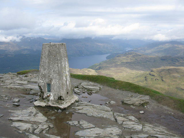
NN2505 : The Cobbler (884 metres)
Alan White
 Photo could not load
NN2605 : Ben Arthur, (The Cobbler)
ronnie leask
 Photo could not load
NN2505 : Loch Long From Ben Arthur Summit
Roddy McLeod
 Photo could not load
NN2505 : Summer conditions
David Medcalf
 Photo could not load
NN2505 : The Cobbler - South Peak and Arthur's Seat from the North Peak
Richard Law
 Photo could not load
NN2505 : On Ben Arthur - approaching the summit as seen from North Peak
Colin Park
 Photo could not load
NN2505 : The Cobbler's summit
Stephen Sweeney

NN2505 : Looking towards the north peak of The Cobbler
David Medcalf
Hill facts and local notes
Classifications
Elevation
887m
2,909 ft
Prominence
260m
Coordinates
56.2130, -4.8080
NN259058
OS Map
56
Explorer: OL39S 364S
At the Summit
The true summit is the rock tor on the Central Peak. Reaching its top involves the exposed “thread the needle” scramble and an equally consequential descent. The surrounding plateau is a sensible stopping point for walkers without the necessary scrambling ability. The lower North Peak is a separate top with steep cliff edges; the South Peak requires rock-climbing skills.
Terrain & Geology
The Cobbler is formed mainly from Dalradian metamorphic rocks of the Beinn Bheula Schist Formation, including schistose arenite, semipelite and pelite. Its striking three-peak outline owes much to large rock-slope failures associated with the glacial landscape. JNCC identifies it as an important mass-movement site.
Views & Scenery
Loch Long, Ben Lomond and the neighbouring Arrochar Alps, including Beinn Narnain and Beinn Ime, are prominent in clear conditions. Views depend on cloud and visibility; there is no need to climb the central tor to enjoy the mountain panorama.
History & Heritage
Name Origin
The name evokes a shoemaker bent over his last, reflected in the Gaelic An Greusaiche Crom. Ben Arthur is the anglicised Beinn Artair; the identity or origin of “Arthur” is uncertain. The summit is not named for a cobbler's hat.
Historical Significance
The Cobbler is a longstanding Scottish rock-climbing venue with strong links to Glasgow climbers. The Narnain Boulders were used as overnight shelters, or howffs, by climbers visiting the mountain.
Getting There & Facilities
Parking
Succoth car park beside the A83 at the head of Loch Long, near Arrochar; published walking-route start grid reference NN294048. Parking charges apply; check current notices, capacity and access before travelling. The mountain path starts across the A83. NN259058 is the summit grid reference and must not be used to locate the car park.
Public Transport
Coaches serve Arrochar from Glasgow; check the current operator timetable and return services. Arrochar & Tarbet railway station is another option, with an additional walking approach to Succoth. Allow for the link from your stop or station and the road crossing, rather than treating transport arrival as the start of the hill route.
Nearby Facilities
Arrochar has refreshments and shops. The National Park facilities page lists toilets at Arrochar/Succoth; check current opening hours and seasonal availability before travelling. Carry the food, water and equipment needed for the hill day.
Safety Information
Known Hazards
- The central summit tor involves exposed scrambling with serious fall consequences. The descent must also be within your ability; turn back before committing if unsure.
- The North Peak has cliff edges and overhangs. The South Peak is a rock-climbing objective, not a walking extension.
- Steep, loose and wet rock can be slippery, particularly on the eastern corrie descent. Take extra care at streams after rain.
- Strong wind, low cloud and rapid weather changes can make navigation and exposed ground hazardous. Carry a map and compass and know how to use them.
- Cross the busy A83 carefully at the Succoth start. Mobile coverage cannot be relied on. In an emergency call 999 and ask for Police, then Mountain Rescue.
Seasonal Hazards
Snow and ice can turn the upper paths and summit area into winter mountaineering terrain. Winter skills, suitable equipment and a conditions-based plan are needed; summer route times and difficulty do not apply. Wet or icy rock and strong winds make the exposed central summit especially serious. Short daylight hours reduce the margin for delays.
General Safety Tips
- Check weather conditions before setting out
- Carry appropriate clothing and equipment
- Let someone know your planned route
- Take a map, compass, and GPS device
- Carry emergency supplies: food, water, first aid kit, torch
Hills
Some common questions about the hills answered
Are there group walks up The Cobbler [Ben Arthur]?
Many walkers use Walkmates to join or organise walks with others. You can check for group walks around The Cobbler [Ben Arthur] through the maps
Are there other walkers around The Cobbler [Ben Arthur]?
Activity varies by location and time, but Walkmates lets you see whether others have shared walks or shown interest in this area. Find other people through the walking friends search walking friends for The Cobbler [Ben Arthur] search or of course create your own walk for The Cobbler [Ben Arthur]
Can I organise a walk to The Cobbler [Ben Arthur]?
Yes. If there aren’t any walks listed already, you can create a walk and make it available for others to join.
If you're signed up to Walkmates, you can create a walk to The Cobbler [Ben Arthur].
How do I find a walk up this hill?
There are often multiple ways to walk this hill, depending on experience and route preference. Walkmates helps you explore walks and routes that others have shared.
Can I suggest a new route up The Cobbler [Ben Arthur]?
Yes. You can suggest or create routes to share with others. Walkmates focuses on the social side of walking, so routes are used to help people organise walks and explore areas together, rather than as detailed navigation tools or route libraries.
Other uses really appreciate knowledgeable walkers sharing their routes. Share your favourite route to The Cobbler [Ben Arthur] here
The is an error or something incorrect about this hill. How do I let you know?
We always strive to keep the information on Walkmates as accurate as possible. If you find an error, please let us know through the contact form and we'll aim to correct it as quickly as possible
Community Discussion
Comments
Location
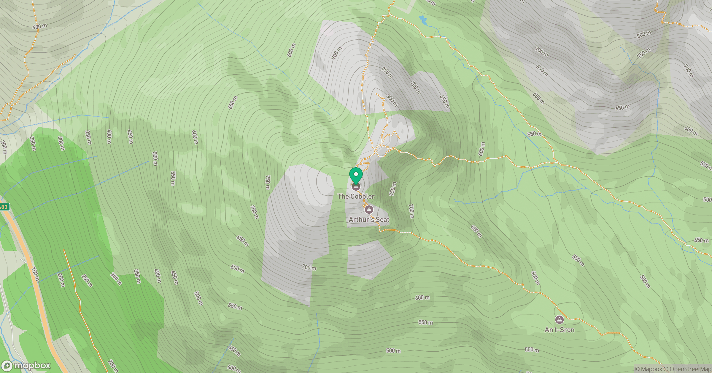
Grid reference: NN259058
View on OpenStreetMapOpens a map in a new tab, centred on the hill.
No comments yet. Be the first.